
Mingsinssu Fm
Type Locality and Naming
The type locality of the Mingsinssu Formation is near Mingxinsi Temple, lying about 15 km northwest of the seat of Zunyi City. No type section was assigned when Liu (1941) proposed the unit. An auxiliary section, the Yankong section, was proposed by Yin in Dong (1997) as representative section of the formation. This is the same auxiliary section for overlying Chintingshan Formation. The section lies near Yankong Town in Yankong Township, about 11 km northeast of the seat of Jinsha County, Bijie City, western Guizhou Province (106°15’E, 27°35’N), and was measured by Zhang Zhenghua, Zhou Zhiyi, and others from the Institute of Geology, Guizhou Headquarter of Petroleum Exploration and the Nanjing Institute of Geology and Palaeontology, Chinese Academy of Sciences in 1970. In this section, the Mingsinssu Formation is 243.9 m thick. The Mingsinssu Formation was named by Liu (1942). The name is derived from Mingsinssu (spelled Mingxinsi in Hanyu Pinyin) Temple on the half way of the Jindingshan Mountain, Honghuagang District, Zunyi City, north-central Guizhou Province. Originally it was called Mingsinssu Bed by Liu (1942) or Mingsinssu Shale by Liu (1948) and was renamed Mingsinssu Formation by Lu (1962), which has been widely used by subsequent authors.
Synonym: (明心寺组)
Lithology and Thickness
The Mingsinssu Formation is a clastic and carbonate sequence. Lower part consists of silty shale, calcareous shale and siltstone with argillaceous lumps, intercalated with calcareous mudstone, marl and marl lenses (134.2 m thick). Middle part is thin-bedded, argillaceous striped limestone with minor interbeds of carbonaceous shale (42.3 m). Upper part consists of greyish or yellowish green mudstone and silty mudstone (77.4 m).
Relationships and Distribution
Lower contact
The Mingsinssu Fm is in conformable contact with the underlying Niutitang Fm. The lower boundary of the formation is defined by disappearance of the black siliceous rock at the top of the underlying Niutitang Fm
Upper contact
The Mingsinssu Fm is in conformable contact with the overlying Chintingshan Fm. The upper boundary is defined by the appearance of gravel-bearing medium- to coarse-grained quartzose sandstone at the base of the overlying Chinghsutung Fm.
Regional extent
The Mingsinssu Formation is exposed in southeastern Yangtze Area of South China Region, distributed in western part of northern Guizhou Province. The formation is stable in lithology except for a tendency of increasing interbeds of archaeocyathids-bearing limestone eastward in the middle part. For example, only one archaeocyathids-bearing bed occurs in the auxiliary section at Yankong, Jinsha, whereas 4‒5 beds in the area of Meitan County, which is about 130 km east. The thickness of the formation ranges between 227 and 464 m in general. It is 155 m thick at Mingxinsi, becomes thicker eastward at Yankong in Jinsha County, about 244 m, and reaches its maximum thickness of 464 m at Meiziwan Village of Meitan County.
GeoJSON
Fossils
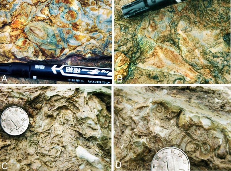
The lower part of the Mingsinssu Formation yields trilobites Zhenbaspis and Qingkoia and bradoriid Tsunyiella. The middle part yields rich archaeocyathids, including Ajacicyathus, Coscinocyathus, and Rotundocyathus and also trilobites Hupeidiscus, Tsunyidiscus Kueichowia, and Pseudoredlichia as well. The upper part yields trilobites Drepanuroides and Szechuanaspis and hyolithids.
[Figure: Archaeocyathids-bearing limestone of the Mingsinssu Formation, northern Guizhou Province, South China. A, B from Maoping-Meiziwan section, Meitang; C, D from Yankong section, Jinsha County. Diameter of the marker pen on A, B = about 10 mm; diameter of the coin on C and D = 24 mm.]
Age
Depositional setting
The formation represents deposits of infralittoral shallow-sea continental shelf environment.
Additional Information